


Lac de Caillauas

petit-pied
User
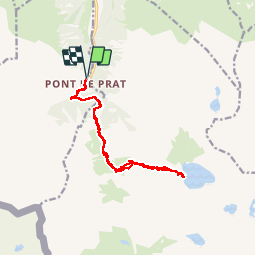

Length
16.2 km

Max alt
2192 m

Uphill gradient
1102 m
Km-Effort
31 km

Min alt
1234 m

Downhill gradient
1102 m
Boucle
Yes
Creation date :
2018-08-12 07:43:56.46
Updated on :
2018-08-12 16:29:42.281
6h11
Difficulty : Medium

FREE GPS app for hiking
 SityTrail
IGN / Geographical institutes
SityTrail Plus
The world is yours!
About
Trail Walking of 16.2 km to be discovered at Occitania, Hautespyrenees, Loudenvielle. This trail is proposed by petit-pied.
Positioning
Country:
France
Region :
Occitania
Department/Province :
Hautespyrenees
Municipality :
Loudenvielle
Location:
Loudenvielle
Start:(Dec)
Start:(UTM)
288009 ; 4735854 (31T) N.
Comments