


2017-10-10_11h56m55_pont de 5

doudet
User
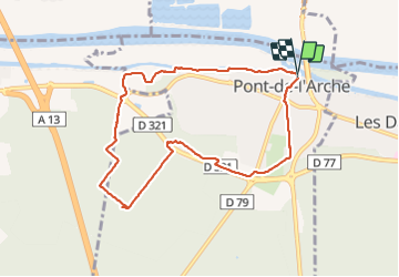

Length
8.1 km

Max alt
64 m

Uphill gradient
107 m
Km-Effort
9.5 km

Min alt
2 m

Downhill gradient
116 m
Boucle
Yes
Creation date :
2018-08-13 07:00:55.112
Updated on :
2018-08-13 07:00:55.112

FREE GPS app for hiking
 SityTrail
IGN / Geographical institutes
SityTrail Plus
The world is yours!
About
Trail of 8.1 km to be discovered at Normandy, Eure, Pont-de-l'Arche. This trail is proposed by doudet.
Positioning
Country:
France
Region :
Normandy
Department/Province :
Eure
Municipality :
Pont-de-l'Arche
Location:
Unknown
Start:(Dec)
Start:(UTM)
366041 ; 5463077 (31U) N.
Comments