


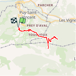
Psv 1800 vers les Tournoux et le lac des Charbonnières

Reich
User

Length
13.2 km

Max alt
1877 m

Uphill gradient
357 m
Km-Effort
17.9 km

Min alt
1727 m

Downhill gradient
354 m
Boucle
Yes
Creation date :
2018-08-14 12:29:06.797
Updated on :
2018-08-14 15:32:10.055
3h48
Difficulty : Difficult
2h30
Difficulty : Medium

FREE GPS app for hiking
 SityTrail
IGN / Geographical institutes
SityTrail Plus
The world is yours!
About
Trail Walking of 13.2 km to be discovered at Provence-Alpes-Côte d'Azur, Hautes-Alpes, Puy-Saint-Vincent. This trail is proposed by Reich.
Description
Très belle rando VTT très roulante sans réelle difficulté (- de 500 m de poussage). Les paysages sont magnifiques !
Photos


Positioning
Country:
France
Region :
Provence-Alpes-Côte d'Azur
Department/Province :
Hautes-Alpes
Municipality :
Puy-Saint-Vincent
Location:
Unknown
Start:(Dec)
Start:(UTM)
300853 ; 4965769 (32T) N.
Comments