


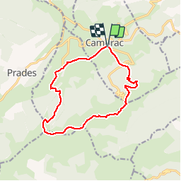
Crêtes de Camurac modif

rigol05
User


--
Difficulty : Medium

FREE GPS app for hiking
 SityTrail
IGN / Geographical institutes
SityTrail Plus
The world is yours!
About
Trail Walking of 14.2 km to be discovered at Occitania, Aude, Camurac. This trail is proposed by rigol05.
Description
Itinéraire entièrement balisé jaune au départ de Camurac (terrain de tennis)
Dans le village de Montaillou suivre les panneaux "crêtes de Camurac" . Monter en sous-bois en direction du col de Balègue. Du col suivre la crête en balcon et profiter d'un panorama à 360°. Roc de Quercourt puis station de ski de Camurac. Le balisage dans la station n'est pas évident à trouver. Au final, après le centre équestre, traversée d' une zone boueuse sur une centaine de mètres.
Positioning
Comments