


Les cascades

Reich
User
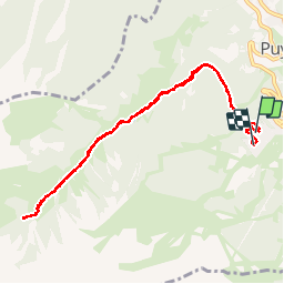

Length
9.3 km

Max alt
2036 m

Uphill gradient
417 m
Km-Effort
14.8 km

Min alt
1699 m

Downhill gradient
380 m
Boucle
Yes
Creation date :
2018-08-16 06:46:01.663
Updated on :
2018-10-07 06:54:21.838
2h22
Difficulty : Easy

FREE GPS app for hiking
 SityTrail
IGN / Geographical institutes
SityTrail Plus
The world is yours!
About
Trail Walking of 9.3 km to be discovered at Provence-Alpes-Côte d'Azur, Hautes-Alpes, Puy-Saint-Vincent. This trail is proposed by Reich.
Description
Rando famille, peu de dénivellé sauf en fin de parcours. Attention aux bords de chemin en arrivant, c'est escarpé.
Photos

Positioning
Country:
France
Region :
Provence-Alpes-Côte d'Azur
Department/Province :
Hautes-Alpes
Municipality :
Puy-Saint-Vincent
Location:
Unknown
Start:(Dec)
Start:(UTM)
300871 ; 4965891 (32T) N.
Comments