Trail On foot Trois-Ponts - SityTrail - Saint-Jacques : double boucle - Photo

SityTrail - Saint-Jacques : double boucle

 suntajl
suntajl

User

© OpenStreetMap contributors
Length
Length
21 km
Max alt
Max alt
508 m
Uphill gradient
Uphill gradient
657 m
Km-Effort
Km-Effort  
30 km
Min alt
Min alt
265 m
Downhill gradient
Downhill gradient
663 m
Boucle
Boucle
Yes
Creation date :
2018-08-20 11:03:03.007
Updated on :
2019-02-19 17:49:39.879

(0 Reviews)

On foot
On foot
5h30
Difficulty : Medium

Scan this QR Code to open this trail in the SityTrail application

FREE GPS app for hiking

Logo SityTrail SityTrail

IGN / Geographical institutes

Download SityTrail from the App Store Download SityTrail from Google Play

Logo SityTrail SityTrail Plus

The world is yours!

Download SityTrail from the App Store Download SityTrail from Google Play Download SityTrail on Huawei AppGallery

About

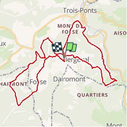
Trail On foot of 21 km to be discovered at Wallonia, Liège, Trois-Ponts. This trail is proposed by suntajl.

Description

Beaux paysages; en général, bons chemins; passage à Rochelinval où a eu lieu un affrontement en 1944 entre des soldats US et des SS Allemands.
ATTENTION: gué à passer à 1km du retour à St Jacques; si trop d'eau, passage possible à travers bois à 100m en aval

Elevation profile

Positioning

Country:
Belgium
Region :
Wallonia
Department/Province :
Liège
Municipality :
Trois-Ponts
Location:
Fosse
Start:(UTM)
703428 ; 5581605 (31U) N.


Close
My subscriptions