


à faire Monal - Lac du clou

Bogapuki
User
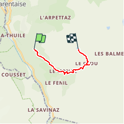

Length
6 km

Max alt
2380 m

Uphill gradient
611 m
Km-Effort
12.2 km

Min alt
1806 m

Downhill gradient
42 m
Boucle
No
Creation date :
2018-08-20 15:19:08.834
Updated on :
2019-02-01 18:30:29.276
2h56
Difficulty : Difficult

FREE GPS app for hiking
 SityTrail
IGN / Geographical institutes
SityTrail Plus
The world is yours!
About
Trail Walking of 6 km to be discovered at Auvergne-Rhône-Alpes, Savoy, Sainte-Foy-Tarentaise. This trail is proposed by Bogapuki.
Positioning
Country:
France
Region :
Auvergne-Rhône-Alpes
Department/Province :
Savoy
Municipality :
Sainte-Foy-Tarentaise
Location:
Unknown
Start:(Dec)
Start:(UTM)
336267 ; 5047945 (32T) N.
Comments