


bel air

lepompi
User
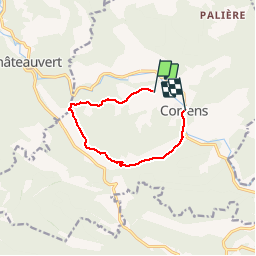

Length
8.3 km

Max alt
338 m

Uphill gradient
179 m
Km-Effort
10.8 km

Min alt
160 m

Downhill gradient
203 m
Boucle
No
Creation date :
2018-08-25 14:26:52.677
Updated on :
2018-08-25 16:20:27.829
1h52
Difficulty : Very easy

FREE GPS app for hiking
 SityTrail
IGN / Geographical institutes
SityTrail Plus
The world is yours!
About
Trail Walking of 8.3 km to be discovered at Provence-Alpes-Côte d'Azur, Var, Correns. This trail is proposed by lepompi.
Description
route et chemin forestier
Positioning
Country:
France
Region :
Provence-Alpes-Côte d'Azur
Department/Province :
Var
Municipality :
Correns
Location:
Unknown
Start:(Dec)
Start:(UTM)
263134 ; 4819641 (32T) N.
Comments