


ballade de La Gravenne

raab
User
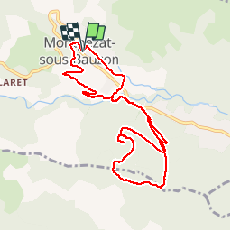

Length
10.9 km

Max alt
791 m

Uphill gradient
443 m
Km-Effort
16.8 km

Min alt
489 m

Downhill gradient
449 m
Boucle
Yes
Creation date :
2018-08-26 12:10:11.576
Updated on :
2018-08-26 15:57:30.252
3h45
Difficulty : Very easy

FREE GPS app for hiking
 SityTrail
IGN / Geographical institutes
SityTrail Plus
The world is yours!
About
Trail Walking of 10.9 km to be discovered at Auvergne-Rhône-Alpes, Ardèche, Montpezat-sous-Bauzon. This trail is proposed by raab.
Positioning
Country:
France
Region :
Auvergne-Rhône-Alpes
Department/Province :
Ardèche
Municipality :
Montpezat-sous-Bauzon
Location:
Unknown
Start:(Dec)
Start:(UTM)
595689 ; 4951530 (31T) N.
Comments