


11-SEP-16 16:23:04

c.chehere
User
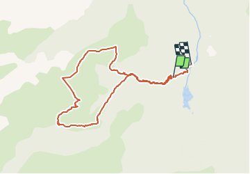

Length
10.3 km

Max alt
1918 m

Uphill gradient
702 m
Km-Effort
20 km

Min alt
1043 m

Downhill gradient
870 m
Boucle
No
Creation date :
2018-08-30 09:28:00.661
Updated on :
2018-09-08 16:40:39.658
3h55
Difficulty : Difficult

FREE GPS app for hiking
 SityTrail
IGN / Geographical institutes
SityTrail Plus
The world is yours!
About
Trail Walking of 10.3 km to be discovered at Occitania, Ariège, Aston. This trail is proposed by c.chehere.
Positioning
Country:
France
Region :
Occitania
Department/Province :
Ariège
Municipality :
Aston
Location:
Unknown
Start:(Dec)
Start:(UTM)
390336 ; 4729695 (31T) N.
Comments