


rohrbach-48km_route

lucienp
User
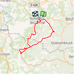

Length
48 km

Max alt
383 m

Uphill gradient
486 m
Km-Effort
54 km

Min alt
218 m

Downhill gradient
485 m
Boucle
Yes
Creation date :
2018-09-11 13:00:55.367
Updated on :
2018-09-12 06:42:31.898
2h07
Difficulty : Very easy

FREE GPS app for hiking
 SityTrail
IGN / Geographical institutes
SityTrail Plus
The world is yours!
About
Trail Road bike of 48 km to be discovered at Grand Est, Moselle, Rohrbach-lès-Bitche. This trail is proposed by lucienp.
Positioning
Country:
France
Region :
Grand Est
Department/Province :
Moselle
Municipality :
Rohrbach-lès-Bitche
Location:
Unknown
Start:(Dec)
Start:(UTM)
373930 ; 5434052 (32U) N.
Comments