


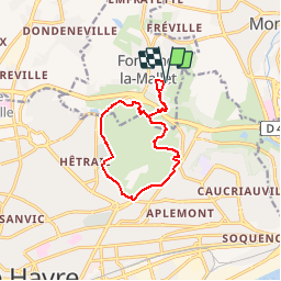
tour de la foret de Montgeon

Laurent53
User

Length
10.7 km

Max alt
93 m

Uphill gradient
212 m
Km-Effort
13.5 km

Min alt
21 m

Downhill gradient
211 m
Boucle
Yes
Creation date :
2018-09-14 15:13:47.418
Updated on :
2018-09-14 15:15:39.183
2h54
Difficulty : Easy

FREE GPS app for hiking
 SityTrail
IGN / Geographical institutes
SityTrail Plus
The world is yours!
About
Trail Walking of 10.7 km to be discovered at Normandy, Seine-Maritime, Fontaine-la-Mallet. This trail is proposed by Laurent53.
Positioning
Country:
France
Region :
Normandy
Department/Province :
Seine-Maritime
Municipality :
Fontaine-la-Mallet
Location:
Unknown
Start:(Dec)
Start:(UTM)
293923 ; 5490671 (31U) N.
Comments