


Bois Belleville & Marbache

PhilippeC54
User
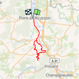

Length
42 km

Max alt
337 m

Uphill gradient
542 m
Km-Effort
50 km

Min alt
177 m

Downhill gradient
542 m
Boucle
Yes
Creation date :
2018-09-23 06:00:24.252
Updated on :
2018-09-23 17:14:01.394
3h29
Difficulty : Easy

FREE GPS app for hiking
 SityTrail
IGN / Geographical institutes
SityTrail Plus
The world is yours!
About
Trail Mountain bike of 42 km to be discovered at Grand Est, Meurthe-et-Moselle, Pont-à-Mousson. This trail is proposed by PhilippeC54.
Description
Le départ réel est depuis le parking du cimetière de Dieulouard
Positioning
Country:
France
Region :
Grand Est
Department/Province :
Meurthe-et-Moselle
Municipality :
Pont-à-Mousson
Location:
Unknown
Start:(Dec)
Start:(UTM)
283575 ; 5420441 (32U) N.
Comments