


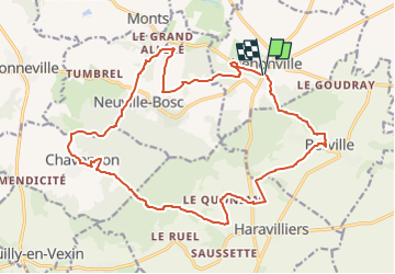
Henonville (Marines nord)

philberard95
User

Length
20 km

Max alt
221 m

Uphill gradient
393 m
Km-Effort
25 km

Min alt
72 m

Downhill gradient
390 m
Boucle
Yes
Creation date :
2018-09-27 15:52:26.399
Updated on :
2023-01-11 12:58:55.677
5h26
Difficulty : Very difficult

FREE GPS app for hiking
 SityTrail
IGN / Geographical institutes
SityTrail Plus
The world is yours!
About
Trail Walking of 20 km to be discovered at Hauts-de-France, Oise, Hénonville. This trail is proposed by philberard95.
Description
Entre Grisy les Platres et Méru
Positioning
Country:
France
Region :
Hauts-de-France
Department/Province :
Oise
Municipality :
Hénonville
Location:
Unknown
Start:(Dec)
Start:(UTM)
430913 ; 5450766 (31U) N.
Comments