


Balade au dessus de Latour de Carol

c.chehere
User
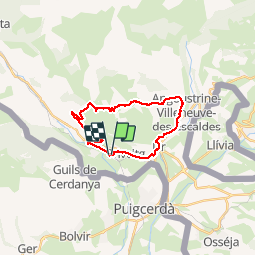

Length
24 km

Max alt
1638 m

Uphill gradient
660 m
Km-Effort
32 km

Min alt
1201 m

Downhill gradient
660 m
Boucle
Yes
Creation date :
2018-10-04 07:53:00.403
Updated on :
2018-10-04 17:01:33.885
7h21
Difficulty : Medium

FREE GPS app for hiking
 SityTrail
IGN / Geographical institutes
SityTrail Plus
The world is yours!
About
Trail Walking of 24 km to be discovered at Occitania, Pyrénées-Orientales, Enveitg. This trail is proposed by c.chehere.
Photos


Positioning
Country:
France
Region :
Occitania
Department/Province :
Pyrénées-Orientales
Municipality :
Enveitg
Location:
Unknown
Start:(Dec)
Start:(UTM)
409999 ; 4701331 (31T) N.
Comments