


P16_18-580

PhilippeC54
User
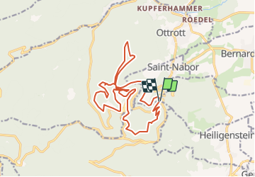

Length
18 km

Max alt
825 m

Uphill gradient
617 m
Km-Effort
26 km

Min alt
538 m

Downhill gradient
610 m
Boucle
Yes
Creation date :
2018-10-18 17:06:02.272
Updated on :
2018-10-18 17:07:47.55
--
Difficulty : Unknown

FREE GPS app for hiking
 SityTrail
IGN / Geographical institutes
SityTrail Plus
The world is yours!
About
Trail Mountain bike of 18 km to be discovered at Grand Est, Bas-Rhin, Obernai. This trail is proposed by PhilippeC54.
Positioning
Country:
France
Region :
Grand Est
Department/Province :
Bas-Rhin
Municipality :
Obernai
Location:
Unknown
Start:(Dec)
Start:(UTM)
382995 ; 5365842 (32U) N.
Comments