


Morchéne

lemuid
User
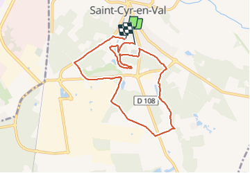

Length
8.6 km

Max alt
119 m

Uphill gradient
69 m
Km-Effort
9.5 km

Min alt
101 m

Downhill gradient
67 m
Boucle
No
Creation date :
2018-10-19 07:19:37.286
Updated on :
2021-07-03 15:28:33.186
2h00
Difficulty : Very easy

FREE GPS app for hiking
 SityTrail
IGN / Geographical institutes
SityTrail Plus
The world is yours!
About
Trail Walking of 8.6 km to be discovered at Centre-Loire Valley, Loiret, Saint-Cyr-en-Val. This trail is proposed by lemuid.
Positioning
Country:
France
Region :
Centre-Loire Valley
Department/Province :
Loiret
Municipality :
Saint-Cyr-en-Val
Location:
Unknown
Start:(Dec)
Start:(UTM)
422743 ; 5297618 (31T) N.
Comments