


W - 2018 - 28 Nolay en Bruyère (rando douce)

clabidault
User
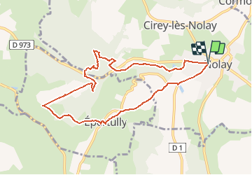

Length
9.1 km

Max alt
453 m

Uphill gradient
204 m
Km-Effort
11.9 km

Min alt
312 m

Downhill gradient
205 m
Boucle
Yes
Creation date :
2018-10-26 21:03:31.075
Updated on :
2018-12-31 14:45:38.038
2h43
Difficulty : Medium

FREE GPS app for hiking
 SityTrail
IGN / Geographical institutes
SityTrail Plus
The world is yours!
About
Trail Walking of 9.1 km to be discovered at Bourgogne-Franche-Comté, Côte-d'Or, Nolay. This trail is proposed by clabidault.
Description
17 participants malgré la pluie au départ
Positioning
Country:
France
Region :
Bourgogne-Franche-Comté
Department/Province :
Côte-d'Or
Municipality :
Nolay
Location:
Unknown
Start:(Dec)
Start:(UTM)
624101 ; 5201104 (31T) N.
Comments