


W - 2018 - 30 Mazenay

clabidault
User
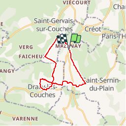

Length
10.7 km

Max alt
443 m

Uphill gradient
217 m
Km-Effort
13.6 km

Min alt
305 m

Downhill gradient
218 m
Boucle
Yes
Creation date :
2018-10-27 08:03:34.423
Updated on :
2018-12-31 14:43:09.969
2h55
Difficulty : Difficult

FREE GPS app for hiking
 SityTrail
IGN / Geographical institutes
SityTrail Plus
The world is yours!
About
Trail Walking of 10.7 km to be discovered at Bourgogne-Franche-Comté, Saône-et-Loire, Saint-Sernin-du-Plain. This trail is proposed by clabidault.
Description
Randonnée facile très beau temps bon rythme 20 participants
Positioning
Country:
France
Region :
Bourgogne-Franche-Comté
Department/Province :
Saône-et-Loire
Municipality :
Saint-Sernin-du-Plain
Location:
Unknown
Start:(Dec)
Start:(UTM)
621528 ; 5196221 (31T) N.
Comments