


Mutrécy 17

rollondesbois
User
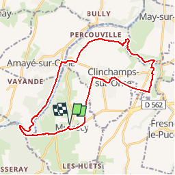

Length
17.2 km

Max alt
91 m

Uphill gradient
197 m
Km-Effort
19.8 km

Min alt
11 m

Downhill gradient
197 m
Boucle
Yes
Creation date :
2018-11-03 11:18:24.142
Updated on :
2018-11-03 11:35:36.989
4h18
Difficulty : Difficult

FREE GPS app for hiking
 SityTrail
IGN / Geographical institutes
SityTrail Plus
The world is yours!
About
Trail Walking of 17.2 km to be discovered at Normandy, Calvados, Mutrécy. This trail is proposed by rollondesbois.
Positioning
Country:
France
Region :
Normandy
Department/Province :
Calvados
Municipality :
Mutrécy
Location:
Unknown
Start:(Dec)
Start:(UTM)
688342 ; 5437885 (30U) N.
Comments