


La randonnée autour de Chazelles

alainjoseph6
User

Length
9.6 km

Max alt
131 m

Uphill gradient
112 m
Km-Effort
11.1 km

Min alt
88 m

Downhill gradient
112 m
Boucle
Yes
Creation date :
2018-11-04 13:54:34.395
Updated on :
2018-11-04 16:28:27.489
2h32
Difficulty : Easy

FREE GPS app for hiking
 SityTrail
IGN / Geographical institutes
SityTrail Plus
The world is yours!
About
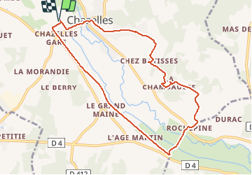
Trail Walking of 9.6 km to be discovered at New Aquitaine, Charente, Chazelles. This trail is proposed by alainjoseph6.
Description
Nous démarrons la randonnée après les terrains de football par la voie verte jusqu'à Rochepine. Le village de chez Bâtisse est sympa. Puis Chazelles.
Photos


Positioning
Country:
France
Region :
New Aquitaine
Department/Province :
Charente
Municipality :
Chazelles
Location:
Unknown
Start:(Dec)
Start:(UTM)
294264 ; 5058255 (31T) N.
Comments