


Autour du Marais

csy95
User
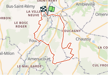

Length
15.6 km

Max alt
154 m

Uphill gradient
276 m
Km-Effort
19.3 km

Min alt
24 m

Downhill gradient
281 m
Boucle
Yes
Creation date :
2018-08-26 10:57:57.066
Updated on :
2018-08-26 10:57:57.076
4h10
Difficulty : Easy

FREE GPS app for hiking
 SityTrail
IGN / Geographical institutes
SityTrail Plus
The world is yours!
About
Trail Walking of 15.6 km to be discovered at Ile-de-France, Val-d'Oise, Bray-et-Lû. This trail is proposed by csy95.
Description
Issu du Topoguide
Positioning
Country:
France
Region :
Ile-de-France
Department/Province :
Val-d'Oise
Municipality :
Bray-et-Lû
Location:
Unknown
Start:(Dec)
Start:(UTM)
401745 ; 5443794 (31U) N.
Comments