


9306048-REC CTM 2018

PhilippeC54
User
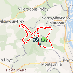

Length
12.9 km

Max alt
389 m

Uphill gradient
217 m
Km-Effort
15.8 km

Min alt
298 m

Downhill gradient
220 m
Boucle
Yes
Creation date :
2018-11-14 07:55:09.972
Updated on :
2018-11-14 07:57:32.782
--
Difficulty : Easy

FREE GPS app for hiking
 SityTrail
IGN / Geographical institutes
SityTrail Plus
The world is yours!
About
Trail Mountain bike of 12.9 km to be discovered at Grand Est, Meurthe-et-Moselle, Montauville. This trail is proposed by PhilippeC54.
Description
Sur les traces de la Grande Guerre
Positioning
Country:
France
Region :
Grand Est
Department/Province :
Meurthe-et-Moselle
Municipality :
Montauville
Location:
Unknown
Start:(Dec)
Start:(UTM)
280789 ; 5422193 (32U) N.
Comments