
Lignières

Titimouilli
User

Length
26 km

Max alt
235 m

Uphill gradient
220 m
Km-Effort
29 km

Min alt
165 m

Downhill gradient
207 m
Boucle
No
Creation date :
2014-12-10 00:00:00.0
Updated on :
2014-12-10 00:00:00.0
1h31
Difficulty : Easy

FREE GPS app for hiking
 SityTrail
IGN / Geographical institutes
SityTrail Plus
The world is yours!
About
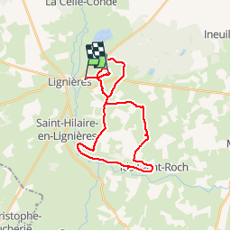
Trail Mountain bike of 26 km to be discovered at Centre-Loire Valley, Cher, Lignières. This trail is proposed by Titimouilli.
Description
Rando VTT boulot
Photos


Positioning
Country:
France
Region :
Centre-Loire Valley
Department/Province :
Cher
Municipality :
Lignières
Location:
Unknown
Start:(Dec)
Start:(UTM)
438022 ; 5177962 (31T) N.
Comments