


Plan B

c.chehere
User
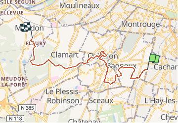

Length
13.3 km

Max alt
172 m

Uphill gradient
239 m
Km-Effort
16.5 km

Min alt
68 m

Downhill gradient
234 m
Boucle
No
Creation date :
2018-11-18 13:31:12.666
Updated on :
2018-11-18 13:53:08.14
3h33
Difficulty : Easy

FREE GPS app for hiking
 SityTrail
IGN / Geographical institutes
SityTrail Plus
The world is yours!
About
Trail Walking of 13.3 km to be discovered at Ile-de-France, Hauts-de-Seine, Bagneux. This trail is proposed by c.chehere.
Description
Au départ de la gare RER B Bagneux jusqu'à la gare RER C "val fleury" de Meudon
Positioning
Country:
France
Region :
Ile-de-France
Department/Province :
Hauts-de-Seine
Municipality :
Bagneux
Location:
Unknown
Start:(Dec)
Start:(UTM)
450111 ; 5404705 (31U) N.
Comments