


balade de Jaujac

raab
User
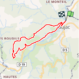

Length
7.9 km

Max alt
574 m

Uphill gradient
248 m
Km-Effort
11.2 km

Min alt
396 m

Downhill gradient
247 m
Boucle
Yes
Creation date :
2018-11-19 13:51:03.963
Updated on :
2018-11-19 16:41:25.24
2h49
Difficulty : Very easy

FREE GPS app for hiking
 SityTrail
IGN / Geographical institutes
SityTrail Plus
The world is yours!
About
Trail Walking of 7.9 km to be discovered at Auvergne-Rhône-Alpes, Ardèche, Jaujac. This trail is proposed by raab.
Positioning
Country:
France
Region :
Auvergne-Rhône-Alpes
Department/Province :
Ardèche
Municipality :
Jaujac
Location:
Unknown
Start:(Dec)
Start:(UTM)
599686 ; 4943587 (31T) N.
Comments