


Chàumont sur Tharonne

lemuid
User
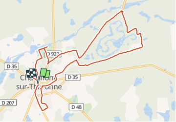

Length
11.3 km

Max alt
148 m

Uphill gradient
102 m
Km-Effort
12.7 km

Min alt
118 m

Downhill gradient
102 m
Boucle
Yes
Creation date :
2018-11-25 09:04:19.483
Updated on :
2018-11-25 17:03:20.93
2h34
Difficulty : Very easy

FREE GPS app for hiking
 SityTrail
IGN / Geographical institutes
SityTrail Plus
The world is yours!
About
Trail Walking of 11.3 km to be discovered at Centre-Loire Valley, Loir-et-Cher, Chaumont-sur-Tharonne. This trail is proposed by lemuid.
Positioning
Country:
France
Region :
Centre-Loire Valley
Department/Province :
Loir-et-Cher
Municipality :
Chaumont-sur-Tharonne
Location:
Unknown
Start:(Dec)
Start:(UTM)
417674 ; 5273585 (31T) N.
Comments