


9342774-EC Fontaine rouge

PhilippeC54
User
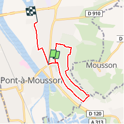

Length
5.9 km

Max alt
250 m

Uphill gradient
95 m
Km-Effort
7.2 km

Min alt
176 m

Downhill gradient
99 m
Boucle
No
Creation date :
2018-11-27 19:40:32.556
Updated on :
2018-11-28 08:18:15.719
28m
Difficulty : Easy

FREE GPS app for hiking
 SityTrail
IGN / Geographical institutes
SityTrail Plus
The world is yours!
About
Trail Mountain bike of 5.9 km to be discovered at Grand Est, Meurthe-et-Moselle, Pont-à-Mousson. This trail is proposed by PhilippeC54.
Description
Openrunner 9342774
Positioning
Country:
France
Region :
Grand Est
Department/Province :
Meurthe-et-Moselle
Municipality :
Pont-à-Mousson
Location:
Unknown
Start:(Dec)
Start:(UTM)
284632 ; 5421186 (32U) N.
Comments