


Igny 08-12

c.chehere
User
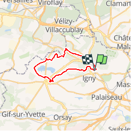

Length
17.5 km

Max alt
161 m

Uphill gradient
167 m
Km-Effort
19.7 km

Min alt
68 m

Downhill gradient
171 m
Boucle
Yes
Creation date :
2018-12-02 19:35:23.328
Updated on :
2019-05-29 06:18:34.125
4h20
Difficulty : Medium

FREE GPS app for hiking
 SityTrail
IGN / Geographical institutes
SityTrail Plus
The world is yours!
About
Trail Walking of 17.5 km to be discovered at Ile-de-France, Essonne, Igny. This trail is proposed by c.chehere.
Description
Départ et arrivée gare RER C "Igny" ou bus 294
Photos


Positioning
Country:
France
Region :
Ile-de-France
Department/Province :
Essonne
Municipality :
Igny
Location:
Unknown
Start:(Dec)
Start:(UTM)
443430 ; 5398835 (31U) N.
Comments