


, balade lablachere chemin de bourbouillet

raab
User
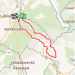

Length
12.9 km

Max alt
269 m

Uphill gradient
167 m
Km-Effort
15.1 km

Min alt
155 m

Downhill gradient
168 m
Boucle
Yes
Creation date :
2018-12-03 10:00:27.08
Updated on :
2018-12-03 14:54:41.25
4h52
Difficulty : Very easy

FREE GPS app for hiking
 SityTrail
IGN / Geographical institutes
SityTrail Plus
The world is yours!
About
Trail Walking of 12.9 km to be discovered at Auvergne-Rhône-Alpes, Ardèche, Lablachère. This trail is proposed by raab.
Positioning
Country:
France
Region :
Auvergne-Rhône-Alpes
Department/Province :
Ardèche
Municipality :
Lablachère
Location:
Unknown
Start:(Dec)
Start:(UTM)
597523 ; 4923585 (31T) N.
Comments