


SityTrail - ADAL_Jouars_16112016

c.chehere
User
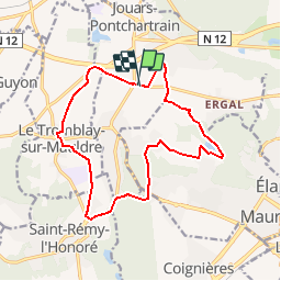

Length
14.4 km

Max alt
177 m

Uphill gradient
200 m
Km-Effort
17.1 km

Min alt
72 m

Downhill gradient
202 m
Boucle
Yes
Creation date :
2018-12-05 14:32:28.33
Updated on :
2018-12-05 14:39:45.678
3h43
Difficulty : Medium

FREE GPS app for hiking
 SityTrail
IGN / Geographical institutes
SityTrail Plus
The world is yours!
About
Trail Walking of 14.4 km to be discovered at Ile-de-France, Yvelines, Jouars-Pontchartrain. This trail is proposed by c.chehere.
Positioning
Country:
France
Region :
Ile-de-France
Department/Province :
Yvelines
Municipality :
Jouars-Pontchartrain
Location:
Unknown
Start:(Dec)
Start:(UTM)
419278 ; 5404585 (31U) N.
Comments