


Dingé

nolsim
User
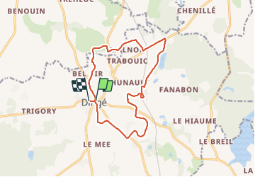

Length
13.8 km

Max alt
110 m

Uphill gradient
110 m
Km-Effort
15.2 km

Min alt
61 m

Downhill gradient
107 m
Boucle
No
Creation date :
2018-12-13 14:26:34.076
Updated on :
2018-12-13 17:03:46.505
2h36
Difficulty : Very easy

FREE GPS app for hiking
 SityTrail
IGN / Geographical institutes
SityTrail Plus
The world is yours!
About
Trail Walking of 13.8 km to be discovered at Brittany, Ille-et-Vilaine, Dingé. This trail is proposed by nolsim.
Positioning
Country:
France
Region :
Brittany
Department/Province :
Ille-et-Vilaine
Municipality :
Dingé
Location:
Unknown
Start:(Dec)
Start:(UTM)
595241 ; 5356846 (30U) N.
Comments