


sennely_Nord

lemuid
User
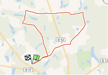

Length
9.6 km

Max alt
133 m

Uphill gradient
73 m
Km-Effort
10.6 km

Min alt
116 m

Downhill gradient
73 m
Boucle
Yes
Creation date :
2018-12-14 09:21:29.11
Updated on :
2018-12-14 19:08:03.858
2h02
Difficulty : Very easy

FREE GPS app for hiking
 SityTrail
IGN / Geographical institutes
SityTrail Plus
The world is yours!
About
Trail Walking of 9.6 km to be discovered at Centre-Loire Valley, Loiret, Sennely. This trail is proposed by lemuid.
Positioning
Country:
France
Region :
Centre-Loire Valley
Department/Province :
Loiret
Municipality :
Sennely
Location:
Unknown
Start:(Dec)
Start:(UTM)
434642 ; 5282133 (31T) N.
Comments