


11-SEP-16 16:23:04

c.chehere
User
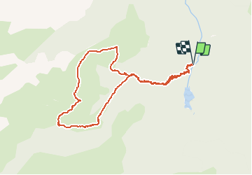

Length
10.6 km

Max alt
1839 m

Uphill gradient
794 m
Km-Effort
21 km

Min alt
1043 m

Downhill gradient
791 m
Boucle
Yes
Creation date :
2018-12-14 14:04:14.892
Updated on :
2020-09-27 12:43:40.486

FREE GPS app for hiking
 SityTrail
IGN / Geographical institutes
SityTrail Plus
The world is yours!
About
Trail of 10.6 km to be discovered at Occitania, Ariège, Aston. This trail is proposed by c.chehere.
Positioning
Country:
France
Region :
Occitania
Department/Province :
Ariège
Municipality :
Aston
Location:
Unknown
Start:(Dec)
Start:(UTM)
390719 ; 4729954 (31T) N.
Comments