


Revel, Arfons, Durfort, Revel

leroj73
User
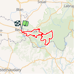

Length
54 km

Max alt
819 m

Uphill gradient
1392 m
Km-Effort
72 km

Min alt
223 m

Downhill gradient
1393 m
Boucle
Yes
Creation date :
2018-12-29 18:43:07.93
Updated on :
2018-12-29 18:45:34.76
4h41
Difficulty : Very difficult

FREE GPS app for hiking
 SityTrail
IGN / Geographical institutes
SityTrail Plus
The world is yours!
About
Trail Mountain bike of 54 km to be discovered at Occitania, Haute-Garonne, Revel. This trail is proposed by leroj73.
Positioning
Country:
France
Region :
Occitania
Department/Province :
Haute-Garonne
Municipality :
Revel
Location:
Unknown
Start:(Dec)
Start:(UTM)
420435 ; 4812016 (31T) N.
Comments