


20190104 st aubin celloville

doudet
User
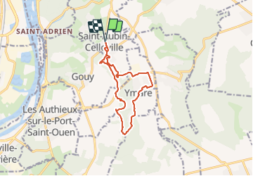

Length
10.9 km

Max alt
146 m

Uphill gradient
173 m
Km-Effort
13.2 km

Min alt
82 m

Downhill gradient
173 m
Boucle
Yes
Creation date :
2019-01-03 13:25:32.703
Updated on :
2021-10-11 08:25:45.523
2h58
Difficulty : Easy

FREE GPS app for hiking
 SityTrail
IGN / Geographical institutes
SityTrail Plus
The world is yours!
About
Trail Walking of 10.9 km to be discovered at Normandy, Seine-Maritime, Saint-Aubin-Celloville. This trail is proposed by doudet.
Positioning
Country:
France
Region :
Normandy
Department/Province :
Seine-Maritime
Municipality :
Saint-Aubin-Celloville
Location:
Unknown
Start:(Dec)
Start:(UTM)
366330 ; 5469738 (31U) N.
Comments