


V - 2019 - Auxey Duresses (rando douce)

clabidault
User
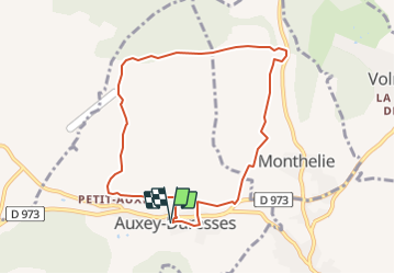

Length
8.2 km

Max alt
422 m

Uphill gradient
191 m
Km-Effort
10.7 km

Min alt
255 m

Downhill gradient
192 m
Boucle
Yes
Creation date :
2019-01-05 14:51:49.531
Updated on :
2019-01-05 14:52:30.525
--
Difficulty : Very easy

FREE GPS app for hiking
 SityTrail
IGN / Geographical institutes
SityTrail Plus
The world is yours!
About
Trail On foot of 8.2 km to be discovered at Bourgogne-Franche-Comté, Côte-d'Or, Auxey-Duresses. This trail is proposed by clabidault.
Positioning
Country:
France
Region :
Bourgogne-Franche-Comté
Department/Province :
Côte-d'Or
Municipality :
Auxey-Duresses
Location:
Unknown
Start:(Dec)
Start:(UTM)
632781 ; 5205111 (31T) N.
Comments