


Entre Lavilledieu et Vogüé

raab
User
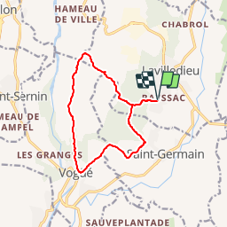

Length
12.5 km

Max alt
329 m

Uphill gradient
235 m
Km-Effort
15.6 km

Min alt
193 m

Downhill gradient
235 m
Boucle
Yes
Creation date :
2019-01-05 19:56:39.028
Updated on :
2019-01-14 21:49:55.079
--
Difficulty : Very easy

FREE GPS app for hiking
 SityTrail
IGN / Geographical institutes
SityTrail Plus
The world is yours!
About
Trail On foot of 12.5 km to be discovered at Auvergne-Rhône-Alpes, Ardèche, Lavilledieu. This trail is proposed by raab.


Positioning
Country:
France
Region :
Auvergne-Rhône-Alpes
Department/Province :
Ardèche
Municipality :
Lavilledieu
Location:
Unknown
Start:(Dec)
Start:(UTM)
614924 ; 4936203 (31T) N.
Comments