


boucle le vaudoué Boissy aux cailles

BRASSENS
User
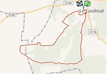

Length
10.4 km

Max alt
126 m

Uphill gradient
135 m
Km-Effort
12.2 km

Min alt
68 m

Downhill gradient
135 m
Boucle
Yes
Creation date :
2019-01-10 16:21:20.735
Updated on :
2019-01-10 16:23:15.188
2h40
Difficulty : Medium

FREE GPS app for hiking
 SityTrail
IGN / Geographical institutes
SityTrail Plus
The world is yours!
About
Trail Walking of 10.4 km to be discovered at Ile-de-France, Seine-et-Marne, Le Vaudoué. This trail is proposed by BRASSENS.
Positioning
Country:
France
Region :
Ile-de-France
Department/Province :
Seine-et-Marne
Municipality :
Le Vaudoué
Location:
Unknown
Start:(Dec)
Start:(UTM)
464233 ; 5355902 (31U) N.
Comments