


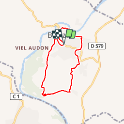
boucle de balazuc Costa de Labeaume

raab
User

Length
7.1 km

Max alt
200 m

Uphill gradient
151 m
Km-Effort
9.1 km

Min alt
131 m

Downhill gradient
152 m
Boucle
Yes
Creation date :
2019-01-14 14:16:01.81
Updated on :
2019-01-14 21:16:25.312
2h20
Difficulty : Very easy

FREE GPS app for hiking
 SityTrail
IGN / Geographical institutes
SityTrail Plus
The world is yours!
About
Trail Walking of 7.1 km to be discovered at Auvergne-Rhône-Alpes, Ardèche, Balazuc. This trail is proposed by raab.
Photos


Positioning
Country:
France
Region :
Auvergne-Rhône-Alpes
Department/Province :
Ardèche
Municipality :
Balazuc
Location:
Unknown
Start:(Dec)
Start:(UTM)
609231 ; 4929070 (31T) N.
Comments