


Amicale_Legny

d.rognon
User
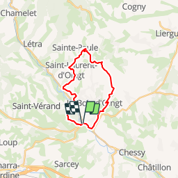

Length
19.4 km

Max alt
567 m

Uphill gradient
586 m
Km-Effort
27 km

Min alt
243 m

Downhill gradient
593 m
Boucle
Yes
Creation date :
2014-12-10 00:00:00.0
Updated on :
2014-12-10 00:00:00.0
5h42
Difficulty : Unknown

FREE GPS app for hiking
 SityTrail
IGN / Geographical institutes
SityTrail Plus
The world is yours!
About
Trail Walking of 19.4 km to be discovered at Auvergne-Rhône-Alpes, Rhône, Légny. This trail is proposed by d.rognon.
Positioning
Country:
France
Region :
Auvergne-Rhône-Alpes
Department/Province :
Rhône
Municipality :
Légny
Location:
Unknown
Start:(Dec)
Start:(UTM)
622114 ; 5084973 (31T) N.
Comments
randonnée agréable ,vue magnifique, seul bémol, un peu trop de goudron