randogps7-377

raab
User
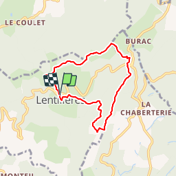

Length
6.5 km

Max alt
590 m

Uphill gradient
190 m
Km-Effort
9 km

Min alt
427 m

Downhill gradient
193 m
Boucle
Yes
Creation date :
2019-01-14 21:41:43.468
Updated on :
2019-01-14 21:51:32.799
--
Difficulty : Very easy

FREE GPS app for hiking
 SityTrail
IGN / Geographical institutes
SityTrail Plus
The world is yours!
About
Trail On foot of 6.5 km to be discovered at Auvergne-Rhône-Alpes, Ardèche, Lentillères. This trail is proposed by raab.
Positioning
Country:
France
Region :
Auvergne-Rhône-Alpes
Department/Province :
Ardèche
Municipality :
Lentillères
Location:
Unknown
Start:(Dec)
Start:(UTM)
604188 ; 4940929 (31T) N.
Comments