


Vigny

Djaie60
User
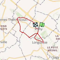

Length
10.4 km

Max alt
122 m

Uphill gradient
140 m
Km-Effort
12.3 km

Min alt
57 m

Downhill gradient
138 m
Boucle
Yes
Creation date :
2019-01-17 11:27:18.753
Updated on :
2019-05-24 16:44:36.923
--
Difficulty : Easy

FREE GPS app for hiking
 SityTrail
IGN / Geographical institutes
SityTrail Plus
The world is yours!
About
Trail On foot of 10.4 km to be discovered at Ile-de-France, Val-d'Oise, Vigny. This trail is proposed by Djaie60.
Positioning
Country:
France
Region :
Ile-de-France
Department/Province :
Val-d'Oise
Municipality :
Vigny
Location:
Unknown
Start:(Dec)
Start:(UTM)
421657 ; 5436539 (31U) N.
Comments