


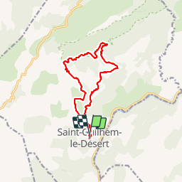
Saint-Guilhem-le-Désert / Roc de la Jarre / Ermitage ND de Belle Grâce

PiloudeBamako
User


5h41
Difficulty : Difficult

FREE GPS app for hiking
 SityTrail
IGN / Geographical institutes
SityTrail Plus
The world is yours!
About
Trail Walking of 14.8 km to be discovered at Occitania, Hérault, Saint-Guilhem-le-Désert. This trail is proposed by PiloudeBamako.
Description
Départ vers le chateau du géant par le GR74; Chemin à droite vers la Baume de l'Olivier; poursuivre jusqu'au Roc de la Jarre; continuer vers le Puech Buissou puis l'Ermitage Notre-Dame de Belle Grâce; Retour par le GR74 (tronçon commun à l'aller).
Photos


Positioning
Comments