![](/images/other/stat-length.png)
![Trail Other activity Airolo - Sella See - Photo](https://media.geolcdn.com/t/1900/400/ext.pjpeg?maxdim=2&url=https%3A%2F%2Fstatic1.geolcdn.com%2Fsiteimages%2Fupload%2Ffiles%2F1545311037marcheuse_200dpi.jpg)
Sella See
jschna
User
![Length](/images/other/stat-length.png)
Length
9.2 km
![Max alt](https://static1.geolcdn.com/siteimages/upload/files/1508320355ic_sort_altitude_max_24dp.png)
Max alt
2310 m
![Uphill gradient](https://static1.geolcdn.com/siteimages/upload/files/1508320355ic_sort_den_pos_24dp.png)
Uphill gradient
306 m
![Km-Effort](/images/other/stat-length.png)
Km-Effort
13.2 km
![Min alt](https://static1.geolcdn.com/siteimages/upload/files/1508320355ic_sort_altitude_min_24dp.png)
Min alt
2092 m
![Downhill gradient](https://static1.geolcdn.com/siteimages/upload/files/1508320355ic_sort_den_neg_24dp.png)
Downhill gradient
304 m
![Boucle](https://static1.geolcdn.com/siteimages/upload/files/16400158638029165_repeat_loop_refresh_sync_direction_icon.png)
Boucle
Yes
Creation date :
2014-12-11 00:00:00.0
Updated on :
2014-12-11 00:00:00.0
![Other activity](https://static1.geolcdn.com/sitytour/trail-icons/900.png)
--
Difficulty : Unknown
![Scan this QR Code to open this trail in the SityTrail application](https://capi.geolives.com/qq0zvz2zws4bq2lad0pu/sitytour/trails/20274/qr.png?size=200)
FREE GPS app for hiking
About
Trail Other activity of 9.2 km to be discovered at Ticino, Distretto di Leventina, Airolo. This trail is proposed by jschna.
Description
Wanderung ab Gotthard Hospiz - der Strasse entlang bis zum See - nach rechts über die Staumauer zur Militärunterkunft - ab da schmaler Wanderweg bis zum Ende des Sees. Die Rückkehr über die Kiesstrasse zurück nach Gotthard Hospiz.
Positioning
Country:
Switzerland
Region :
Ticino
Department/Province :
Distretto di Leventina
Municipality :
Airolo
Location:
Unknown
Start:(Dec)
Start:(UTM)
466854 ; 5155971 (32T) N.
Comments
Trails nearby
![Trail On foot Airolo - Strada Bassa - Photo](https://media.geolcdn.com/t/375/260/ext.jpg?maxdim=2&url=https%3A%2F%2Fmedia.geolcdn.com%2Ff%2Ff81afdc9-f182-46ad-8198-37dc98335834.jpeg)
![On foot On foot](https://static1.geolcdn.com/sitytour/trail-icons/100.png)
Strada Bassa
On foot
Medium
Airolo,
Ticino,
Distretto di Leventina,
Switzerland
![](/images/other/stat-length.png)
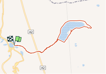
19.2 km | 27 km-effort
6h 3min
![](https://static1.geolcdn.com/siteimages/upload/files/16400158638029165_repeat_loop_refresh_sync_direction_icon.png)
No
![Trail On foot Airolo - Strada degli Alpi - Photo](https://media.geolcdn.com/t/375/260/ext.jpg?maxdim=2&url=https%3A%2F%2Fmedia.geolcdn.com%2Ff%2F28d1a178-b79f-4e14-a216-ad8ff4ed8b5f.jpeg)
![On foot On foot](https://static1.geolcdn.com/sitytour/trail-icons/100.png)
Strada degli Alpi
On foot
Easy
Airolo,
Ticino,
Distretto di Leventina,
Switzerland
![](/images/other/stat-length.png)
13.2 km | 19.8 km-effort
4h 30min
![](https://static1.geolcdn.com/siteimages/upload/files/16400158638029165_repeat_loop_refresh_sync_direction_icon.png)
No
![Trail On foot Airolo - Strada Alta - Photo](https://media.geolcdn.com/t/375/260/ext.jpg?maxdim=2&url=https%3A%2F%2Fmedia.geolcdn.com%2Ff%2Fa11c2b9a-53fe-4f2a-84f2-135767ac283d.jpeg)
![On foot On foot](https://static1.geolcdn.com/sitytour/trail-icons/100.png)
Strada Alta
On foot
Very difficult
Airolo,
Ticino,
Distretto di Leventina,
Switzerland
![](/images/other/stat-length.png)
44 km | 67 km-effort
15h 17min
![](https://static1.geolcdn.com/siteimages/upload/files/16400158638029165_repeat_loop_refresh_sync_direction_icon.png)
No
![Trail On foot Airolo - Ospizio San Gottardo-Hospental - Photo](https://media.geolcdn.com/t/375/260/ext.jpg?maxdim=2&url=https%3A%2F%2Fmedia.geolcdn.com%2Ff%2F7913350d-e445-44c6-bc03-c3845fc867df.jpeg)
![On foot On foot](https://static1.geolcdn.com/sitytour/trail-icons/100.png)
Ospizio San Gottardo-Hospental
On foot
Easy
Airolo,
Ticino,
Distretto di Leventina,
Switzerland
![](/images/other/stat-length.png)
9.1 km | 11.6 km-effort
2h 38min
![](https://static1.geolcdn.com/siteimages/upload/files/16400158638029165_repeat_loop_refresh_sync_direction_icon.png)
No
![Trail On foot Airolo - Lago della Sella - fixme - Photo](https://media.geolcdn.com/t/375/260/ext.jpg?maxdim=2&url=https%3A%2F%2Fmedia.geolcdn.com%2Ff%2Fbac52592-0270-43aa-838e-a06b26324961.jpeg)
![On foot On foot](https://static1.geolcdn.com/sitytour/trail-icons/100.png)
Lago della Sella - fixme
On foot
Easy
Airolo,
Ticino,
Distretto di Leventina,
Switzerland
![](/images/other/stat-length.png)
3 km | 5.4 km-effort
1h 13min
![](https://static1.geolcdn.com/siteimages/upload/files/16400158638029165_repeat_loop_refresh_sync_direction_icon.png)
No
![Trail Road bike Airolo - Airolo 3 cols - Photo](https://media.geolcdn.com/t/375/260/ext.jpg?maxdim=2&url=https%3A%2F%2Fmedia.geolcdn.com%2Ff%2Fc7e30b72-19e3-4b6a-9b61-119f8d0a22db.jpeg)
![Road bike Road bike](https://static1.geolcdn.com/sitytour/trail-icons/201.png)
Airolo 3 cols
Road bike
Very difficult
Airolo,
Ticino,
Distretto di Leventina,
Switzerland
![](/images/other/stat-length.png)
100 km | 144 km-effort
8h 43min
![](https://static1.geolcdn.com/siteimages/upload/files/16400158638029165_repeat_loop_refresh_sync_direction_icon.png)
Yes
![Trail Road bike Airolo - Airolo barrage Ambri - Photo](https://media.geolcdn.com/t/375/260/ext.jpg?maxdim=2&url=https%3A%2F%2Fmedia.geolcdn.com%2Ff%2F9a5712b3-59c7-4bf7-903a-892ab1fd81eb.heic)
![Road bike Road bike](https://static1.geolcdn.com/sitytour/trail-icons/201.png)
Airolo barrage Ambri
Road bike
Very difficult
Airolo,
Ticino,
Distretto di Leventina,
Switzerland
![](/images/other/stat-length.png)
28 km | 43 km-effort
2h 35min
![](https://static1.geolcdn.com/siteimages/upload/files/16400158638029165_repeat_loop_refresh_sync_direction_icon.png)
Yes
![Trail On foot Airolo - Motto Bartola-Ospizio San Gottardo - Photo](https://media.geolcdn.com/t/375/260/ext.jpg?maxdim=2&url=https%3A%2F%2Fstatic1.geolcdn.com%2Fsiteimages%2Fupload%2Ffiles%2F1545311037marcheuse_200dpi.jpg)
![On foot On foot](https://static1.geolcdn.com/sitytour/trail-icons/100.png)
Motto Bartola-Ospizio San Gottardo
On foot
Easy
Airolo,
Ticino,
Distretto di Leventina,
Switzerland
![](/images/other/stat-length.png)
4.6 km | 6.6 km-effort
1h 29min
![](https://static1.geolcdn.com/siteimages/upload/files/16400158638029165_repeat_loop_refresh_sync_direction_icon.png)
No
![Trail Other activity Airolo - y10_val_canaria - Photo](https://media.geolcdn.com/t/375/260/ext.jpg?maxdim=2&url=https%3A%2F%2Fstatic1.geolcdn.com%2Fsiteimages%2Fupload%2Ffiles%2F1545311037marcheuse_200dpi.jpg)
![Other activity Other activity](https://static1.geolcdn.com/sitytour/trail-icons/900.png)
y10_val_canaria
Other activity
Very easy
Airolo,
Ticino,
Distretto di Leventina,
Switzerland
![](/images/other/stat-length.png)
16.2 km | 28 km-effort
6h 27min
![](https://static1.geolcdn.com/siteimages/upload/files/16400158638029165_repeat_loop_refresh_sync_direction_icon.png)
No