


7 - Sauvelade - Aroue

norihtom
User
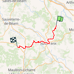

Length
31 km

Max alt
265 m

Uphill gradient
501 m
Km-Effort
38 km

Min alt
97 m

Downhill gradient
604 m
Boucle
No
Creation date :
2019-02-02 12:04:04.248
Updated on :
2019-05-05 10:24:33.057
8h08
Difficulty : Difficult

FREE GPS app for hiking
 SityTrail
IGN / Geographical institutes
SityTrail Plus
The world is yours!
About
Trail Walking of 31 km to be discovered at New Aquitaine, Pyrénées-Atlantiques, Sauvelade. This trail is proposed by norihtom.
Positioning
Country:
France
Region :
New Aquitaine
Department/Province :
Pyrénées-Atlantiques
Municipality :
Sauvelade
Location:
Unknown
Start:(Dec)
Start:(UTM)
684335 ; 4806178 (30T) N.
Comments