


marche à pied

randolea
User
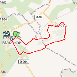

Length
7 km

Max alt
280 m

Uphill gradient
97 m
Km-Effort
8.3 km

Min alt
210 m

Downhill gradient
99 m
Boucle
Yes
Creation date :
2019-02-03 09:20:01.589
Updated on :
2019-02-03 12:35:12.568
1h55
Difficulty : Very easy

FREE GPS app for hiking
 SityTrail
IGN / Geographical institutes
SityTrail Plus
The world is yours!
About
Trail Walking of 7 km to be discovered at Grand Est, Meurthe-et-Moselle, Essey-et-Maizerais. This trail is proposed by randolea.
Positioning
Country:
France
Region :
Grand Est
Department/Province :
Meurthe-et-Moselle
Municipality :
Essey-et-Maizerais
Location:
Unknown
Start:(Dec)
Start:(UTM)
705997 ; 5422184 (31U) N.
Comments