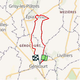
Génicourt

Djaie60
User

Length
10.8 km

Max alt
157 m

Uphill gradient
136 m
Km-Effort
12.6 km

Min alt
74 m

Downhill gradient
136 m
Boucle
Yes
Creation date :
2019-02-04 17:58:46.682
Updated on :
2019-02-04 18:03:35.361
2h45
Difficulty : Difficult

FREE GPS app for hiking
 SityTrail
IGN / Geographical institutes
SityTrail Plus
The world is yours!
About
Trail Walking of 10.8 km to be discovered at Ile-de-France, Val-d'Oise, Génicourt. This trail is proposed by Djaie60.
Positioning
Country:
France
Region :
Ile-de-France
Department/Province :
Val-d'Oise
Municipality :
Génicourt
Location:
Unknown
Start:(Dec)
Start:(UTM)
431940 ; 5437721 (31U) N.
Comments