


r.genette
User
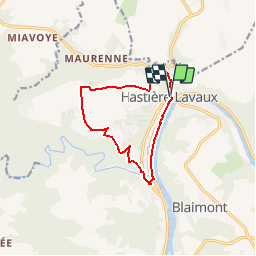

Length
9.8 km

Max alt
260 m

Uphill gradient
227 m
Km-Effort
12.9 km

Min alt
95 m

Downhill gradient
231 m
Boucle
Yes
Creation date :
2019-02-06 11:05:28.421
Updated on :
2019-02-06 14:30:56.512

FREE GPS app for hiking
 SityTrail
IGN / Geographical institutes
SityTrail Plus
The world is yours!
About
Trail of 9.8 km to be discovered at Wallonia, Namur, Hastière. This trail is proposed by r.genette.
Positioning
Country:
Belgium
Region :
Wallonia
Department/Province :
Namur
Municipality :
Hastière
Location:
Hastière-Lavaux
Start:(Dec)
Start:(UTM)
630186 ; 5564275 (31U) N.
Comments
Sympa...