


Chatel Guyon le mont chalusset

jeanic63
User
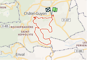

Length
7.8 km

Max alt
487 m

Uphill gradient
176 m
Km-Effort
10.1 km

Min alt
395 m

Downhill gradient
175 m
Boucle
Yes
Creation date :
2019-02-07 10:28:17.008
Updated on :
2021-04-11 12:24:00.835
--
Difficulty : Very easy

FREE GPS app for hiking
 SityTrail
IGN / Geographical institutes
SityTrail Plus
The world is yours!
About
Trail On foot of 7.8 km to be discovered at Auvergne-Rhône-Alpes, Puy-de-Dôme, Châtel-Guyon. This trail is proposed by jeanic63.
Description
départ chatel guyon parking de la piscine
Positioning
Country:
France
Region :
Auvergne-Rhône-Alpes
Department/Province :
Puy-de-Dôme
Municipality :
Châtel-Guyon
Location:
Unknown
Start:(Dec)
Start:(UTM)
505634 ; 5085124 (31T) N.
Comments